![Sea_to_Shining_Sea_c[1]](/sites/g/files/awx4151/f/images/Sea_to_Shining_Sea_c%5B1%5D_1469450630.jpg)
| Days 21 |
Miles 1,154 |
Shouters 2 |
Tandems 3 |
Chapter One
Day 18 - 5/3/11 (29 miles)
This was a day of rejoicing and celebration. It was the final portion of the first section of our adventure. It was an absolutely lovely day, mid-50s, light wind, no clouds. We rolled out of Rico Hotel at about 11:45. We again followed the Dolores River with gentle climbs through amazing scenery. Including yesterday and today, we'd follow the Dolores for almost 50 miles of striking beauty.
After about 9 miles, we were above 10,000 feet. The traffic was light and friendly, and we saw several other cyclists, who were apparently local, as they were traveling without the multiple bags we have.
After 12 miles, we reached the summit of Lizard Head Pass, 10,222 feet, our highest summit of the trip (and ever!). Although we've heard that this was a light snow year for Colorado, there seemed to be plenty at the top of the pass.
![lizardhead_pass_op[1]](/sites/g/files/awx4151/f/images/lizardhead_pass_op%5B1%5D_1469451092.jpg)
We enjoyed a few quick miles of descent, a small climb out of the town of Ophir, and then a surprisingly tough climb of 500 feet in less than 2 miles. Luckily, there was plenty of natural beauty to make the climb worthwhile.
Then it was basically an easy pedal into the town of Telluride, and we easily found the Hotel Telluride, our lodging for the next two nights. Because this is their off-season—after skiing and before film and music festivals—we got an amazing corner room with a deck, a view of the ski slopes and surrounding mountains, complete with, yes, robes and slippers.
Kim enjoyed another soak with the special bath salts mentioned in previous entries. Then we took the tandem to the local bike shop, Paragon Ski and Sport, and left it in the highly capable hands of Cormac. He'll tune it up and keep it until we return to begin Chapter 2.
We had dinner at La Cucina, which was very good, and then returned to the hotel to relax. It's been so great to receive the various e-mails and text messages offering support and encouragement. Thank you! It's been a wonderful adventure.
Chapter 1 is DONE!
Day 17 - 5/2/11 (38 miles)
![icicles_op[1]](/sites/g/files/awx4151/f/images/icicles_op%5B1%5D_1469451092.jpg)
Today was the first sunny, cloudless, windless morning we can remember. We had breakfast at the Ponderosa and then packed up the bike for departure. It was an excellent meander through the valley along the Dolores River. It was still pretty cold—see photos of icicles—but we did see two kayakers on the river and a few patches of green fields.
We had our first (and, hopefully, only) flat tire about 7 miles into the ride. Unfortunately, it was the rear tire, so it was a bit more complicated, but maintenance man Andy was able to take care of it, and we were on the road again.
At our scheduled rest stop, Stoner Creek Cabins, we found it under construction. Cabins host Ray let Kim warm up in his cabin as the crew continued their work. She was very grateful for a few minutes in heated space. The whole crew wished us safe travels as we continued on our way.
We continued the relatively gradual climb (2,000 feet total throughout the 38 miles), and the snow-capped mountains came into view. At about 2:30, we arrived in Rico, Colorado, and the Rico Hotel. We expected very basic accommodations in this town of about 350. Instead, we found a comfortable room and the amazing chef Eamonn O'Hara. Our dinner was wonderful. When he asked Kim if she'd prefer pasta to the salmon or beef entrée, she expected standard SpaghettiOs.
Instead, it was a delicious, fully flavored combination of spices in cream sauce, vegetables, and spice-encrusted tofu. Andy raved about his Asian-inspired salmon with sticky rice and sautéed squash and carrots. He also loved his crabcake appetizer.
Then, for dessert, it was crème brûlée with caramel sauce and a few candied nuts sprinkled on top. A total feast. When we talked with Eamonn after dinner we learned that after moving to the U.S., he spent 9 years as chef at Hotel Bel Air in Beverly Hills, where he worked with Wolfgang Puck, and the next 11 years at the Peaks Hotel in Telluride, Colorado, before relocating to the more relaxed Rico Hotel. If you can stop by and experience his skills, you will be thrilled.
Breakfast was equally yummy, with individual mini-soufflés, fruit, and “perfect” coffee (per Andy). We enjoyed our conversation with the only other guest at the hotel, a traveler from Wisconsin, and shared recommendations regarding National Park stops.
And off we go to Telluride.
Day 16 - 5/1/11 (62 miles)
![welcome_to_CO_op[1]](/sites/g/files/awx4151/f/images/welcome_to_CO_op%5B1%5D_1469451092.jpg)
We woke today to sunny skies and light winds, so although the forecast was still for wind and snow or rain, we decided to give the first 27 miles toward Dove Creek a try. Thankfully, we made an eastward turn at the start to change the ever-present northern headwind to more of a crosswind. The topography was rolling hills, so while the net elevation gain wasn't significant, there was still climbing. After about 11 miles, we turned south and received the benefit of the Blessed Tailwind.
In Dove Creek, Colorado (Yes, we made it to our destination state!), we stopped for a late morning snack at an Everything Store (gas/groceries/fast food/sporting goods/florist). Then we decided to keep moving as it appeared that we were actually following the forecasted weather, with the assistance of our now-friendly north wind, toward Dolores, 35 miles ahead.
After more rolling topography and plenty of truck traffic, we turned onto our final highway of the day, which had much less traffic, but appeared to take us more into the weather. It began to snow. This did make us nervous for several minutes, but a few turns in the road later, we were back to “just cold” without precipitation.
When Andy spotted "Hilltop Gas Station," we gave a cheer and coasted down the hill into Dolores and checked in to the Dolores Mountain Inn, just 62 miles away from our Chapter 1 destination, Telluride, Colorado.
We're heading to dinner at Dolores River Brewery, and as we type this, it's snowing—sideways. Welcome to Colorado in May.
Day 15 - 4/30/11 (23 miles)
23 miles doesn't seem like much of an accomplishment, unless you've pedaled 87 miles and 126 miles in the immediately preceding days and the temperature is in the mid-30s, the headwind is in the upper 20s with gusts into the 30s, and you're climbing 1,500 feet. Then, you're just glad to make it to the Wayside Inn in Monticello, Utah, and have dinner at PJ's Burgers. The result was our slowest average speed of 8.6 mph.
There were several stops along the way, some to stretch and for Kim to catch her breath; some to walk for a bit to keep the circulation going in our arms. Kim was thrilled when we arrived at Woody's Mini-Mart for some hot chocolate and heated, wind-free space.
The owner/host at the Wayside was very friendly and helped us locate a place that was open for dinner. The room was comfy and quiet. We're going to take tomorrow a bit at a time given weather forecast for snow and wind.
Day 14 - 4/29/11 (126 miles)
![colorado_river_op[1]](/sites/g/files/awx4151/f/images/colorado_river_op%5B1%5D_1469451092.jpg)
Well, where to start? This was our biggest day ever. It was also the first time either of us had ridden more than 100 miles (a “century”) in a day. As is becoming customary, our day began with climbing, followed by more climbing. We left Hanksville about 8:15, and met our first fellow cross-country cyclist, a guy from Sparks, Nevada, who left there on April 10 to “get in shape, lose some weight, and see where he ended up." He's lost 25 pounds so far and has been going about 30 miles a day.
Within just a mile or two after passing the Sparks rider, we spotted our next group of cyclists, another couple on two bikes, with the woman pulling a small trailer which held their dog. They'd started from Durango, Colorado, and were headed to St. George, Utah, where they intended to rent a car and drive back. They had interesting stories to tell of their ride, where they'd been camping, and they confirmed that the potential midway point hotel for today is closed.
We wound our way through the spectacular Glen Canyon, just missing being hit by a 3-foot diameter tumbleweed at about 25 mph. We were also serenaded, as we have been across all the windy basins, by the haunting tones of wind blowing through the power lines. Once we reached the valley beyond the canyon, after crossing yet another cattle guard, we encountered our first “free-range” cattle. In a way they were “posturing” cattle, as they took a relatively aggressive stance and kept their eyes on us the entire time, a few even taking steps towards us. This would have been a much more significant impact that the tumbleweed!
Following some rolling climbs and descents, we began our descent towards Lake Powell, which is really the Colorado River, since it appears the lake hasn't been full in years, perhaps decades. After crossing the Colorado, we began our next climb when we noticed yet another group of cyclists by the side of the road, so we stopped to chat. It turns out this group of five 20-something-year-old riders had been on the road for just less than a year, touring through all 49 of the continental states. Talk about an adventure!
About 30 miles later, at mile 72, we passed through Fry Canyon and confirmed that this would not be an option for overnight accommodations. We decided to keep going, stopping every 30 minutes to assess our status and create a campsite if needed. As we climbed toward Natural Bridges National Monument, a coyote crossed the road ahead of us. He seemed well-fed, so we weren't concerned.
Making our way through incredible canyon views, stopping as we'd agreed, we continued to make progress. One climb was a half-mile ascent on roadway etched into the side of a tremendous cliff wall and through a narrow, two-lane notch dynamited through the wall to reach the next valley.
Then, just was we were starting to feel close to our destination, we noticed that the road made a sharp turn around the top of a cliff wall and realized that we'd have to climb to make the turn. This was not a happy realization. This section, of about one-and-a-half miles, was daunting, to say the least. We would pedal until we needed to stop, walk for several yards to catch our breath, and then pedal some more. Kim expected to see the town of Blanding waiting for us at the top. Instead it was prairie, complete with dropping temperatures as the sun began to set.
About two miles later, we came to a gas station. We stopped to ask where the town was, and were told it was 3 miles ahead. This was 3 miles into sustained 25 mph headwinds with gusts to 35 mph. We were in our lowest gear, pedaling with all the strength we had left and moving at 6 mph on relatively flat ground, and the town still wasn't getting any closer.
Finally, we spotted a Super 8 motel and pronounced ourselves “home." Our 13-hour travel day concluded—126 miles, 6,200 feet of climbing, about 13 Power Bars, and 12 liters of water. The staff of the motel was excellent, helping us locate a restaurant that was still open. The showers were hot, the bed comfy. Excellent!
Day 13 - 4/28/11 (87 miles)
![two_of_us_at_Capital_Reef[1]](/sites/g/files/awx4151/f/images/two_of_us_at_Capital_Reef%5B1%5D_1469451092.jpg)
Well, it was VERY difficult to leave Boulder Mountain Lodge (Boulder Mtn. Lodge)! Dinner last night at their award-winning Hell's Backbone Grill ranks among the best dining experiences we've had, anywhere. We kept expecting somebody famous to walk through the door. Our server was excellent, Andy's trout wonderful, Kim's pumpkin ”jenchiladas” with corn sauce were outstanding, and the chive potato soup was out of this world. The dessert, dark gingerbread with vanilla ice cream and caramel sauce, was the perfect ending.
Our room was wonderful, and their breakfast this morning—oatmeal, made with steel-cut oats and a delicious crab-apple swirl on top—was also excellent. If you're ever doing a tour of the Utah parks, we highly recommend stopping here.
Then, reality set in. We bundled up, with temperatures in the mid-40s, and set out on our longest day yet. The climb began almost immediately, gentle at first, but definitely UP. The climb to the summit (9,600 feet) was about 2,800 feet in 13 miles. A few miles in, our complete absence of critter-spotting came to a dramatic end, when we rode through a mini-herd of 9 deer—6 on one side, 3 on the other, and then came across another 11 deer within a few hundred feet.
The climb yielded more striking views across huge vistas. We finally said good-bye to Mount Garfield, which we'd ridden on each side of throughout the last three days (Kim recommends blasting a tunnel.). Ahead, we could see a tremendous grove of aspens, which we eventually climbed through. Due to the very long winter and late spring, they were still bare. What a great sight this must be in the fall.
We had numerous supportive waves, cheery beeps from passing cars, and even one of the guests from Boulder Mountain who pulled alongside to encourage our climb. At one of the many scenic overlooks, about 10 people joined together in cheers and applause. This didn't make the climb easier, but much more enjoyable. At one point we were passed by a group of about 10 German motorcyclists, complete with cameraman and support vehicle, making their journey along Route 66.
From the summit, we experienced our first 10% downgrade, then rolled through several more 8% climbs and descents until we arrived at Torrey. We stopped at a Taco Time restaurant, conveniently adjacent to a Texaco station, for lunch. We were “entertained” by the nonstop banter from the manager to her Tom Petty Jr. look-alike employee. A far cry from last night's dinner.
MVP of the day was our gently rolling coast through Capital Reef National Park. Seeing this by bicycle, or, okay, convertible, is the only way to see this amazing park. The rock formations are truly spectacular, and if you like rocks as much as Kim does, it's pretty close to heaven. About three quarters of the way through the park, we stopped to talk with two road-bike cyclists, who, given their bike equipment and discussion of their recent rides, were very experienced riders. They were more eager to hear about our trip and helped by taking the first picture of the two of us since we left Fallon, Nevada.
All this activity basically got us halfway to our destination. The remaining miles took us through many steep, if not too long, climbs and descents, past more amazing scenery, bordering the Fremont River for about 38 miles, all with blustery winds, which were sometimes headwinds, and occasionally, Blessed Tailwinds.
Finally, after about 8 hours total time, and 6&fraq12; hours of pedal-time, we coasted into Hanksville, Utah. Our lodging at the Whispering Sands isn't as luxurious as last night, but it's comfortable, indoors, and has heat. We may not be able to say the same tomorrow night, as we'll be traveling across 122 miles without services. More news to follow, once we reach Blanding, Utah!
Day 12 -4/27/11 (28 miles)
We spent a wonderful night in our exceptionally appointed guest room at Canyons B&B, with a very helpful hostess, Cate, providing lots of information on our next few days of riding. She also made an excellent breakfast and sent us happily on our way. Canyons B&B.
Without a cloud in the sky, very light winds, and no sideways snow, it was a great start to a short but challenging day through the amazing Escalante Grand Staircase National Monument. It is a truly spectacular area.
![panorama_view_from_hogback_ridge[1]](/sites/g/files/awx4151/f/images/panorama_view_from_hogback_ridge%5B1%5D_1469451092.jpg)
After climbing yet another summit, we dropped into a stone bowl as we descended to the Escalante River. Just before the river, we stopped in at Kiva Coffeehouse, which had been recommended by Cate. The structure is built into the side of the cliff and not really visible from the road. The view from the all-glass dining area is of the canyon below. The service was friendly, and the coffee was excellent (per Andy), and the hot chocolate very yummy (per Kim). Again, as we have seen throughout the trip, the majority of the visitors were European—French this time. We've met Germans, Japanese, and Italians, which has been surprising.
We continued on through the stunning canyon, with Kim snapping pictures from the moving bike. Unfortunately, this was all uphill, but without wind, and moderate temperatures. Finally, the whole panorama became visible—a true 360 degree view for miles—from the section of the road known as the Hog Back. It's a ridge with steep drop-offs on each side of the road. Surprisingly, there were no shoulders, guardrails, or other safety features. We stayed well inside the white line, and all the motorists were polite, friendly, and traveling at safe speeds.
We then had an 8% descent to a scenic viewing area, where we could see our destination, Boulder, Utah, across the valley. As we geared up, once again thanking Kurt of Tour of Nevada City for all his help with frame bags, wind-blocking/high visibility jackets, and so on, a large motor home (the Phaeton model—a motorized house pulling a car), also pulled into the area. The very friendly wife jumped out and came over to chat with us, saying, “That's how I'd love to be seeing this area!” We offered to trade, with little hesitation.
She filled us in on the climb awaiting us tomorrow. Then she remarked that “at least it's all downhill into Boulder from here." Actually, it was about a 300 foot climb in a mile from the floor of the valley to our destination. Apparently, the Phaeton has the ability to moderate terrain, which we're going to look into.
We arrived at our home for the night, the Boulder Mountain Lodge, another beautiful spot, more like a spa really, complete with crested robes.
Day 11 - 4/26/11 (60 miles)
Following a good dinner at Harold's and conversation with Harold's daughter, Kristy, about their move from Las Vegas 26 years ago, founding the restaurant, adding cabins 11 years ago, and buying the inn next door last year, we had a good night's sleep. We woke this morning to the sound of wind whistling around the cabin. During breakfast, nicely prepared by Harold, the former head chef for the Nugget in Vegas, and served by Kristy, we watched the clouds close in. As we were finishing, it began to snow, sideways—propelled by 25+ mph winds.
![red_canyon_hoodoos_op[1]](/sites/g/files/awx4151/f/images/red_canyon_hoodoos_op%5B1%5D_1469451092.jpg)
We contemplated staying another day, but the weather forecast for the other side of the Red Canyon summit was much better, so we decided to get moving. As we loaded the bike, the snow diminished a bit, and we headed into the beautiful Red Canyon. We saw some excellent Easter Island-ish formations, and, yes, they really are red. There was a nice bike path through the park, so we got a break from traffic management for about 8 miles.
After leaving the park, we continued to climb towards the turn-off for Bryce Canyon. The wind was still strong, and the temperature was very chilly. We were glad we'd decided to wear just about all the clothing we brought with us. We made a brief stop at Bryce Canyon City and then descended to Tropic, which was anything but, passing by the amazing cliffs and formations that are part of the Escalante Grand Staircase National Monument. If you haven't seen this part of the world, we highly recommend it.
We stopped again at Cannonville, along the Paria River, at a motel/mini-mart/gas station, and got to meet the owner and a couple of locals who wanted to review our route to Telluride and shared a comprehensive tour of the owner's various cacti (one is named Medusa given the way it appears). We then headed east, then north, into the strong headwind as we crossed the basin.
Then, up, up, up through the Blues. This group of mountains definitely did make us “blue” both because it was freezing and because it was some of the most aggressive climbing so far. Then, the ultimate blues-maker was the appearance of reaching the summit, making a quick downhill, turning left around a cliff, only to see a hill before us that had the switchbacks and grade of the road by Emerald Bay in Tahoe, only significantly longer. We ultimately needed to walk a section of this climb, making quicker progress than we were on the bike. Finally, we reached the summit (7,600 feet) and began the final 20 miles of the journey.
Then, we felt the first few stings of blowing ice and snow, carried by the significant headwind. This continued for what seemed like forever but was probably 20 minutes, until we reached the rolling valley floor. There were some stretches without headwind, but we were very glad to reach Escalante, after 4 hours and 20 minutes of pedal time and 5 hours and 30 minutes of total travel time.
Our overnight accommodations were at the very comfortable, well-appointed, and well-supplied with hot water Canyons Bed and Breakfast. The Wi-Fi at the B&B wasn't working as advertised, and the Verizon coverage was next to nil, so no Internet access.
The forecast for tomorrow is for greatly reduced wind and more mild temperatures in the mid-50s. That will be sooooo welcome.
Day 10 - 4/25/11 (65 miles)
![10000_feet_op[1]](/sites/g/files/awx4151/f/images/10000_feet_op%5B1%5D_1469451092.jpg)
Today, after two days of rain and snow, the skies finally cleared. It was a beautiful, windless, sunny day in Cedar City when we headed out of town at about 7:30 A.M. Our climb began almost immediately up 8% grades and ended 4,000 feet later at 10,000 foot elevation, after 18 miles of riding. See Andy's enthusiastic pose at the top of the climb.
We had to navigate through narrow canyons, with lots of rock- and mudslides, and we learned that when the Utah DOT posts a sign to be alert for rocks in the road, this must be taken seriously. See photo.
![rock_in_road_op[1]](/sites/g/files/awx4151/f/images/rock_in_road_op%5B1%5D_1469451092.jpg)
We climbed through snow and slush and found that the snow was deep enough to become our bike stand as we suited up for the cold descent. We also learned that it's VERY cold if a car drives by and splatters you with slush.
Following the descent, before we took on the final 21 miles, we stopped at Tod's in Long Valley Junction (8,000 feet) for a break. Andy's assessment that the coffee was excellent and was supported by other visitors from Seattle, who were equally impressed. These breaks are much nicer than standing in the middle of Nevada, buffeted by winds.
The final stretch along Highway 89 was well paved but very busy with lots of semitrucks, so we had to be extra aware. Andy, MVP for the day, due to his excellent climbing strength, also navigated the rumble strips as we tried to stay clear of traffic.
This was supposed to be the easy section of the day, but with a 15 mph headwind, it required plenty of work to go downhill. We arrived at our Red Canyon lodging, Harold's Place Restaurant and Cabins, at about 3:10 P.M. and checked into our comfy cabin, with Andy looking forward to the dinner special—prime rib.
Day 9 - 4/24/11 (0 miles)
Today was a very relaxed day: caught up on reading, made lodging reservations for most of the remaining days of this section, and started reviewing possible schedule options for the second section of the ride. The weather was rainy on and off, but it's scheduled to clear by tomorrow morning. Everybody keep their fingers crossed!
Day 8 - 4/23/11 (0 miles)
![Bryce1_op[1]](/sites/g/files/awx4151/f/images/Bryce1_op%5B1%5D_1469451092.jpg)
Today, with the rental car, we drove the next section of the journey as an exploration of days to come. There were intermittent showers, snow flurries, low clouds, and fog. A great day to be in a car. We crossed a 10,000-foot summit, which we've tentatively scheduled for Monday, taking Easter Sunday to rest and letting the current weather system move through.
We made a brief stop in Bryce Canyon, and although visibility was poor, we could see some of the spectacular formations, complete with a dusting of snow, and we will look forward to visiting the park again on another trip.
We checked out a couple of lodging options on our way back to Cedar City, made another stop at the Bike Route for some additional items, stocked up on Balance Bars, trail mix, and had lunch at Applebee's before we turned in the rental car.
Day 7 - 4/22/11 (57 miles)
![Bryce_2_op[1]](/sites/g/files/awx4151/f/images/Bryce_2_op%5B1%5D_1469451092.jpg)
After an excellent evening in Milford, Utah, our first night in the state, including a warm soak for Kim, using excellently named bath salts (“Tired Old A$$”) from friend Carolyn, in the first tub we've encountered, we got an early start for our next destination, Cedar City.
After days on the road with absolutely no services, we stopped at our first mini-mart since Fallon, Nevada, in Minersville. The friendly cashier saved the day for Kim by loaning her clippers and a file to correct a Lycra-snagging fingernail. You can surely imagine the potential disaster if this was not resolved.
The road out of Minersville was great, with a Blessed Tailwind (Yes, we've adopted an official name for tailwinds.), for the significant climb up from the valley. The valley was the first agricultural zone we've seen, and we also spotted the world's largest raven in the tall grass by the side of the road. His beak was at least four inches long.
The rolling climb ended after about 25 miles at the 6,500-foot summit. At that point, we could actually see Cedar City, 32 miles away, across the expansive valley. Kim remarked, “I can't believe it. It's 11:00 A.M., and we can see our destination!” It was exciting and slightly intimidating to see the goal, but sooooo tiny. The 14-mile descent to the valley floor was an excellent, relaxing ride, interrupted only by stealth cattle guards.
As we approached our first, actual city (population 20,527), confirmed by Wal-Mart trucks and a bowling alley, we stopped for a short break at the Maverick station. Their shady picnic table area was excellent. We enjoyed a conversation with an area farmer who thought he and his wife might enjoy riding a tandem as means for reviewing their fields and calculating seed requirements.
We then proceeded through downtown to the local bike shop, the Bike Route, where owner Mark Gunderson earned MVP of the day for helping us with bike maintenance—new back tire, brake adjustment, and other supplies, following the severe downhills in Nevada. Mark commented that the bike seemed to be doing very well, a tribute to Duane and Connie at Tour of Nevada City who helped us get ready for the trip. Andy had talked with Mark several times en route for his recommendations on which roads were open, places to stay, and so on. He's the inventor and patent-holder for the “fat tire” Mountain Trike (www.BikeRouteShop.com), which we're thinking could be handy transportation around Grass Valley.
While Mark did the bike work, we enjoyed lunch at the All-American Classic Diner, and co-diners helped us with recommendations of where to stay. We ended up at the Marriott Springhill Suites, a rough choice, but we did our best to endure. We were able to rent a car from Enterprise and enjoyed a hearty dinner at Applebee's.
We'll be taking a rest day tomorrow, after seven straight days of pedaling, to check out the route ahead, available lodging and Bryce Canyon.
Day 6 - 4/21/11 (85 miles)
![Neverending_road_op[1]](/sites/g/files/awx4151/f/images/Neverending_road_op%5B1%5D_1469451092.jpg)
We got off to an early start with an excellent breakfast cooked by Terry—custom granola, yogurt, and fruit for Andy, and homemade oatmeal for Kim. He was an excellent host, an SF transplant who lives in Salt Lake City and works every other week at Silver Jack (which he owns). He's currently working with the neighbors and other Nevada residents to try to stop the project to send local water to Las Vegas.
We began cycling at 8:30, trying to get ahead of the predicted winds. This was not successful. We pedaled for the first 3+ hours into a 25+ mph headwind. After going through Garrison, Utah (welcome to Mountain Time), just 7 miles into the ride, the sign warned us, “Next Services 78 miles."
We spent the next 25 miles crossing the Snake Valley and the Antelope Valley Wash, basically climbing the entire way against the wind. We even passed a small lake with white caps headed our way. Critter Spotting #1: a burrowing owl.
At this point, we noticed that no cars had passed us going in our direction (maybe about five in the opposite direction) since the start of our ride. Ultimately, only 15 cars would pass us, headed our direction, in the entire 85-mile journey.
Following what seemed like a never-ending traverse of yet another basin (see photos of “forever road”), we began the first of two summit climbs. Luckily, we turned slightly east and had more of a crosswind. The climb was filled with beautiful scenery and excellent rock formations with amazing striations and colors soaring up from the valley floor.
The 11-mile descent from Wah Wah Summit, an 8% downgrade, was very windy and not too much fun, and it may have shortened the life of our rear tire and brake pads. Following another impressive basin traverse, we began the final climb of the day through the San Francisco Mountains to Frisco Summit (6,445 feet). This climb was well assisted by a much appreciated tailwind.
Upon reaching the top, we began the best part of the day: a 14-mile descent into Millford, Utah. It was a much more gentle descent, requiring no pedaling to maintain 30 mph. Excellent! Then, just as the road began to level out, we reached the edge of town and our comfy hotel, the Oak Tree Inn.
This was our most challenging day so far. We're glad it went so well. More to come.
Day 5 - 4/20/11 (63 miles)
![Connors_Pass_op[1]](/sites/g/files/awx4151/f/images/Connors_Pass_op%5B1%5D_1469451092.jpg)
We started the day with a decent breakfast buffet at the Ramada Inn, and then we began pedaling towards Baker, our last stop in Nevada. We quickly left civilization on yet another stretch of Highway 50. In previous days, we'd been gratefully assisted by tailwinds. Today was a different experience. There were significant headwinds across Steptoe Valley.
Partway across, a car pulled alongside to inquire if we had enough water or needed any supplies for our journey. (Excellent Stranger Assist #2). Then, just a few minutes later, another car pulled alongside, and the driver shouted, “Andy Bernadett?” Kim answered in the affirmative, since everywhere we go, somebody knows Andy. The driver called out that his name was Terry, owner of the Silver Jack, the motel/mini-mart/restaurant/espresso bar/art gallery/wine cellar extravaganza where we were to stay overnight. Apparently, not that many tandems ride across in a given day, so he guessed it was us.
The scenery was beautiful and the rain clouds, for the most part, didn't impact the travel. We then climbed up to Connors Summit, the highest point of the trip (7,722 feet). The wind was blowing so hard that, even with a 6% downgrade, we had to pedal to get to 25 mph.
At the end of the descent, we stopped at Major's Place, a combination bar and RV park with antlers of various origins hanging on the fence surrounding the property. We took about a 20-minute break inside, asked the friendly locals about the next section of the ride, and then headed back out on the road.
Heading into Spring Valley, we could see the road go all the way across (8 miles of totally straight road), then begin the climb to our second summit of the day, and the last of the 13 summits we crested in Nevada. There was a bit less headwind, which was welcome. Then we began the climb up to Sacramento Pass (7,154 feet). It wasn't as high as the previous one, but it was more elevation gain from the valley floor. We took a break about 3/4 of the way up and walked the bike for a few hundred yards to use some different muscles, progressing at about half the speed of pedaling.
After the walk, we biked the rest of the way to the summit and bundled up for the 1700-foot, 15-mile descent into Baker (population 52). We found Terry's place, had a great dinner, and connected to his Wi-Fi in the shop while listening to his Mozart collection for a couple of hours.
Day 4 - 4/19/11 (79 miles)
![roughing_it_op[1]](/sites/g/files/awx4151/f/images/roughing_it_op%5B1%5D_1469451092.jpg)
After a wonderful night's sleep at the Eureka B&B, and a yummy breakfast prepared by the owner, Mary. We packed up the bags, loaded the bike, and headed for Ely. The first stop was Pinto Summit (7,351 feet), about an 800-foot climb in 3 miles, just to be sure we were awake. There was a dusting of fresh snow from the brief, but windy, showers last night. Although it was sunny, with fluffy clouds, the temperature was in the low 40s, which made the descent into Newark Valley quite cold.
As we headed through the valley, the driver of an oncoming pick-up gave a huge wave. As we were wondering if it was Larry (MVP from yesterday), we recognized Margi in the car following. Thus we encountered the first people we actually knew on Highway 50.
The second stop was Pancake Summit (6,521 feet). After passing and being passed by many mining-related trucks, one came by carrying only two tires (the largest tires either of us had ever seen in our lives), which Larry had told us were for the “little” mine trucks. It was headed for one of the many mines in Eureka County, which makes it the second richest county in Nevada.
Following the descent and a traverse of 13 miles across the valley—which we could see completely across—we made the climb to the third summit of the day, Little Antelope Summit (7,438 feet). We saw no antelope, little or big, during the climb. In fact, both of us have been surprised at how little wildlife we've seen so far—no deer, no elk, no antelope, just a rabbit, a couple of chipmunks, and a badger.
After another descent and traverse of a valley with greener pastures, a few ranches, and the beautiful Butte Mountains to the north, we began climb #4 up to Robinson Summit (7,607 feet), the highest elevation we've attained on the bike (until tomorrow when we go above 7,700 feet). Following this climb, we began the last stretch of 17 miles of flat/descent towards Ely.
During this part of the journey a minivan passed us, also going towards Ely. Then they turned around and pulled over on the opposite shoulder inquiring if we had sufficient water and where we were headed. After we let them know we were almost to our stop for the night, they turned around and passed us again. Only then did we notice their license plate frame—“Cyclists do it for centuries." Very nice of them to check on us.
We arrived at our lodging for the night, Ramada Inn, and enjoyed a well-cooked meal at Evah's restaurant. We're not too sure if all the food has really been as good as it's tasted, or if we're just really hungry.
Day 3 - 4/18/11 (72 miles)
![loaded_bike_op[1]](/sites/g/files/awx4151/f/images/loaded_bike_op%5B1%5D_1469451092.jpg)
The plan for today was to travel from Austin to Eureka, yes, still in Nevada. It was a great day of riding, starting with cloudy skies, and from the very first pedal stroke of the day a 1,000-foot climb to the top of Austin Summit (7,484 feet) in the first 3 miles. We almost grabbed onto the bumper of a big-rig that was chugging up the road along with us. Once we reached the top, there was a brief descent of a few hundred feet, then a 300-foot climb.
When we crested Bob Scott Summit (7,195 feet), it started raining. We had a 10-mile descent at about 40 mph through rain and gusty winds. Then we enjoyed a wonderful tailwind through the basin and another 800-foot climb up to Hickison Summit (6,594 feet). The best thing about this was that it was followed by a 40-mile flat/descending stretch of well-paved road. We made great time, supported by our “third pedaler," a 15-20 mph tailwind.
One new “policy” was adopted today, following the near-heartbreaking incident of yesterday. Since leaving Fallon, given the weight of the bike, we'd been dismounting and walking the bike across the numerous cattle guards we encountered. At one of the guards on Highway 722, as we dismounted and prepared to walk across, a gust of wind blew the plastic map case off of its snapped connection on the front handlebar bag, and, before we could catch it, down it went below the cattle guard.
Fortunately, we were able to retrieve it, and Andy has created a “seat belt” to prevent this from happening again. Another piece of instruction from the road!
We enjoyed spectacular views of the Toiyabe Range, albeit more so when we were on the downhill side than when we were approaching them! There were amazing horizon-to-horizon mountain ranges, yet daunting since we knew that, somehow, we'd have to snake through them. Today was the first day that we ended at about the same elevation we left—6,500 feet.
Safety Tip #1: When a giant triple-trailer hay truck passes you from the opposite direction, hold on tight to the bike. Big gusts of wind from trucks going 70-80 mph make the Loneliest Highway very exciting. Overall, the roads were great, very smooth, and the drivers very courteous.
MVP of the day goes to computer guy Larry in Eureka, Nevada. Late yesterday evening, the laptop, despite being “protected” by antivirus software, was invaded by malware. Kim worked with the excellent tech staff at Commonwealth for quite a while in the morning, but remote access wasn't able to kill the virus. They were willing to have us ship the computer to them for a thorough cleaning, and then ship it back to us someplace on the route. To say that Kim wasn't excited about this is a total understatement.
Andy called Mary, the owner of the B&B we had reservations in for tonight, Eureka B&B, and she helped coordinate an appointment with Larry following the class he was teaching at the Eureka Senior Center. Just after we arrived, Mary gave us a ride over and introduced us to Larry and Margi. We then spent the next five hours with each other, with the excellent telephone support from Jeff of Commonwealth Tech Support, working to disable and remove this nasty virus. Ultimately successful, which you guessed since you're reading this post, the four of us enjoyed a great Mexican dinner at La Fiesta. Larry and Margi shared many tales of their life adventures, and it was a pleasure to get to know them. If you ever need computer assistance in Eureka, they come with our highest recommendation. As you read this, please, give them a hearty round of applause!
Day 2 - 4/17/11 (66 miles)
![Carol_Summit_op[1]](/sites/g/files/awx4151/f/images/Carol_Summit_op%5B1%5D_1469451092.jpg)
Day 2 started with some excellent coffee and a solid breakfast at the Middlegate Station bar/restaurant/mini-mart/gas station/and, as it turns out, brothel. The eggs and pancakes were the best (aka only) in town. After refilling all of the water bottles and loading up the bike, we headed towards our destination, Austin, Nevada.
Following conversation the night before with a few locals, including the innkeepers, we elected the more elevation-challenging, yet scenic, course for the ride. After just a few miles on the Loneliest Highway, which included passing by the recently downed, nationally famous, Shoe Tree, we turned onto the Even More Loneliest Highway (#722) and proceeded to climb, and climb, and climb towards Carol Summit. We finally found trees and even encountered about 4 square feet of shade.
![7000ft_NV_op[1]](/sites/g/files/awx4151/f/images/7000ft_NV_op%5B1%5D_1469451092.jpg)
After about 3 hours, 2900 feet, and 21 miles, we reached the top. Due to the temperature and wind, we donned extra gear and made the amazingly quick 20-mile descent and traversed across Smith Creek Valley at about 30 mph. We spotted what we believe to be a badger, but not much other wildlife.
We saw huge dust devils, fortunately quite a distance away, unusual clouds, and the spectacular snow-covered Toiyabe range, with 10,000+ foot peaks, and a few horizon-to-horizon contrails. After 41 miles from the summit, we rejoined Highway 50 for the last few miles into Austin, which also turned out to require a 900-foot climb. This was not Kim's favorite part of the day.
After meeting Mary, the sister of the Middlegate owner, who owns the Owl and the next-door pub, we found our way to the Union Street Lodging Bed & Breakfast. The owner, Dee, escorted us to our room, the Emma Nevada Suite. When we mentioned the Emma Nevada House in Nevada City, she remarked that Emma lived in Austin until she was 16, so this was truly her home.
We enjoyed another good dinner at the International Café & Bar—pork chops for Andy and veggie pizza for Kim. Then we walked down to the Chevron mini-mart to restock and met a local woman with a pole-vault/decathlete champion son and champion pole-vaulter grandson. Then, as we discussed our plan for Day 3, José, the clerk behind the counter, pulled out his iPad, launched Google Earth, traced out the route, and downloaded a weather report. Could be a few showers. More later.
Day 1 - 4/16/11 (49 miles)
![Fallon_depart_op[1]](/sites/g/files/awx4151/f/images/Fallon_depart_op%5B1%5D_1469451092.jpg)
With tax season wrapped up, albeit late Friday night, we got everything packed, and with the help of Car Courier Matt, we headed to Fallon, Nevada, the official start for this section of the tour. We arrived at a Stop & Shop on Highway 50, grateful to note that we had all the stuff we'd intended to bring, loaded up the bike, and bid farewell to Matt, and motorized transportation.
The Loneliest Highway has rumble strips down the middle and just outside of the white lines on each side, with about 12 inches of paved shoulder outside the white line. So we had to ride just inside of the white line. Kim kept her neon yellow jacket on and an eye on the rearview mirror, waving to cars and trucks as they approached. The drivers were very friendly, giving us plenty of space and their own friendly waves.
Rolling through the salt flats, the most interesting features were the names, messages, peace signs, and hearts “written” on the sand in black rocks. This continued for miles and miles, with Kim's favorite being “I'm spun."
After a few short climbs and being passed by one toy hauler after another, we came to Sand Mountain: a huge mountain of sand—no, really—with quads and dirt bikes climbing all over it.
![motel[1]](/sites/g/files/awx4151/f/images/motel%5B1%5D_1469451092.jpg)
After quite a long climb as we continued past the turn-off to see Berlin-Ichthyosaur, following the Pony Express trail, which celebrated its 150th anniversary in 2010, we started a descent towards Middlegate Station. Kim noticed a group of shabby trailers and a couple of trees a few hundred yards off the road and jokingly remarked, “I'll bet that's where we're staying," followed by a few chuckles, right until Andy turned the bike onto that very road. Please, see pictures of our “motel” accommodations—front and back. Our room was about letter E.
Well, looks can be deceiving, and owners were very kind, friendly CA transplants, who'd owned the property for 26 years. Andy enjoyed a great prime rib dinner, and Kim's garden burger and fries tasted pretty excellent, too.
Then, we realized that our other fellow lodgers were there for a bachelor party. Due to the thinness of the walls, ill-fitting windows, and the volume of their conversations, we were almost attendees at the party. There was a full host of characters, complete with T-shirt sayings inappropriate for this journal.
We went to bed much earlier than they did.
The Prologue
Day 3 - 3/3/11 (66 miles)
After significant weather delays, resulting in the highest snowpack in the Sierra in more than 50 years, we were able to take on the third section of the ride. Just slightly shy of “completely goofy," we had a 16-hour day and put about 460 miles on the cars to ride 66 miles on the tandem. Without a chauffeur this time, we first drove both cars back to the ending point from Day 2—Greg's house near Watt Avenue in Sacramento. We unloaded the bike and then drove both cars to the end point for the day, the school parking lot in Omo Ranch, California (in the middle of nowhere, about 30 miles southeast of Placerville. Elevation 3600 feet).
We left the bike hauler there, and drove the other car back to Greg's house. Then we began the ride, again enjoying the American River bike path. Since it was the first decent weather in almost two months, the trail was full of riders, joggers, and walkers in both directions. We exchanged waves with two other tandems going the opposite direction. After enjoying the views of the river, avoiding a near head-on collision with a Boy Scout coming around a blind corner on the wrong side of the trail (Yes, there is a dividing stripe painted on the path.), and another Scout shouting, “She's not even pedaling," we reached Folsom. We pedaled right by Folsom State Prison and transitioned to Green Valley Road.
![Panda_Express_op[1]](/sites/g/files/awx4151/f/images/Panda_Express_op%5B1%5D_1469451092.jpg)
We spotted a huge crane hunting for lunch, along with lots of other wildlife, in Mormon Island Wetlands State Park, which borders the road. Then, the climbing began. We would ultimately climb about 5,000 feet over the last two thirds of the ride. At Missouri Flat Road, we needed a break, which included Andy lying down on the pavement to eat Skittles and recover. A kindly motorist stopped to inquire if all was well, where we were going, and after being assured that we were just “resting," he went on his way. After about 15 minutes, we continued on and were thrilled to make it to Diamond Springs and find Panda Express waiting for us—see photo of enthusiastic diners.
After lunch, with batteries recharged, we continued winding through the El Dorado County wine country, which is packed with vineyards, climbing, and climbing, and climbing on Bucks Bar Road (quickly renaming the road). Kim decided it was better to ride with her eyes closed than to see the unending hills. When a couple in a convertible passed us, clearly enjoying their ride, we, if only briefly, wondered why we weren't touring in our own convertible.
![school_op[1]](/sites/g/files/awx4151/f/images/school_op%5B1%5D_1469451092.jpg)
On one of the all-too-quick descents, we crossed the Cosumnes River, and, yes, began to climb again. After a final stretch break at Fair Play, we committed to the last 7 miles and 1,300 feet of climbing. It was 5:00. Finally, we saw snow on the roadside and knew we were getting close. At about 6:15, we rounded another corner, on yet another hill, and saw the 25 mph speed limit sign warning us of a school zone. Neither of us had ever been so happy to see a 25 mph sign.
We enjoyed dinner (but not the understaffed, excruciatingly slow service) at Bocconato Trattoria.The prix fixe menu from chef Giovanni Gaudio was excellent, but we'd unknowingly scheduled our ride for Passport Weekend, when the wineries join together for a tasting spectacular. No wonder there had been so much traffic! Then, we returned to Greg's to recover the other car and drove back to Grass Valley for showers and collapsed into bed.
Given the accumulated snow, we'll be skipping the portion of the ride from Omo Ranch to Fallon, Nevada, and catch that section when the snow's melted. Instead, we'll start the first chapter of the journey in Fallon on April 16, and, many things permitting, make it to Telluride, Colorado, by the end of our vacation. Stay tuned!
Day 2 - 2/13/11 (25 miles)
After a relaxed start and an excellent breakfast at Black Bear Diner, we embarked on a short ride to Sacramento. To Kim, however, it felt like plenty of time on the bike seat after the long day 1 adventure.
The ride along the Yolo Causeway, which is basically a sidewalk to Highway 80, was LOUD, but flat (hurrah!). Aside from a short section on cobblestones (!) in Old Sacramento and a bit of construction, it transitioned easily to the American River Bike Path. This bike/jogging/walking path was wonderful. No traffic, no lights, friendly people, smooth pavement, and interesting views of the city helped the time and miles fly by. We reached Watt Avenue at about 11:00 A.M. and made the short trip to Greg's house to pick up the Subaru. An excellent second day and a great start to the adventure.
Day 1 - 2/12/11 (74 miles)
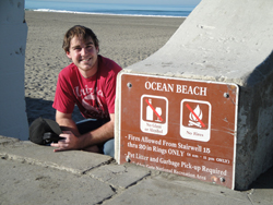
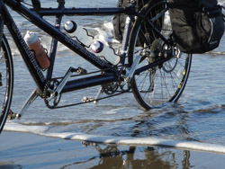
With the generous, early-morning help of our friend, Matt, we left Grass Valley at 6:00 A.M., and drove two cars to Sacramento, where we left our Subaru at the home of another wonderful friend, Greg, for pick-up on Day 2. Then we headed to the official starting point, Ocean Beach, California, just west of San Francisco. We could not have had a better day—sunny, no wind, just a bit chilly to start, but lovely by noon.
After dipping the back tire in the Pacific Ocean, we began our bike ride to Ocean City, Maryland, by riding through Golden Gate Park, through downtown San Francisco, on Market Street (Andy's idea to do this section of the ride on a Saturday was brilliant!), and ended up at the Market Street ferry station. While Andy enjoyed a yummy fried-egg sandwich, we talked with some other tandem riders, Pat and Dennis, and had a long conversation with Ron of San Francisco Specialty Food, who is interested in starting to ride tandem with his wife. Then we boarded the ferry for the hour-long ride to Vallejo. Andy was quite pleased with the great coffee while on board, and we enjoyed watching the sea lions play on and around the navigation markers.
We left the Vallejo marina about 1:00 and pedaled 66 miles to Davis, arriving at 6:00, just as it was getting dark. The ride was beautiful - green hills, happy cows, some trees already in full bloom, friendly drivers, lots of other cyclists - and very well mapped by Adventure Cycling. Thank goodness for a bag of Skittles, which helped fuel us for the last 10 miles.
Kim's going to keep a tally of all the people we see riding tandem - 1 so far; and all the people who shout to Andy, “she's not even pedaling!” - 1 so far.
After we arrived in Davis, we had a great dinner at our favorite restaurant, Crepeville, and a comfy overnight at the Best Western, two blocks away.